
Thank you for supporting this site ❤️
Make a donation
Make a donation
Gear up for your next adventure:
As an Amazon Associate, this site earns from qualifying purchases at no extra cost to you.
Sendamal topographic map
Click on the map to display elevation.
Thank you for supporting this site ❤️
Make a donation
Make a donation
Gear up for your next adventure:
As an Amazon Associate, this site earns from qualifying purchases at no extra cost to you.
About this map
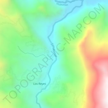
Name: Sendamal topographic map, elevation, terrain.
Location: Sendamal, Huasmin, Celendín, Cajamarca, Perú (-6.83224 -78.26350 -6.79922 -78.24908)
Average elevation: 1,971 m
Minimum elevation: 1,591 m
Maximum elevation: 2,731 m
Thank you for supporting this site ❤️
Make a donation
Make a donation
Gear up for your next adventure:
As an Amazon Associate, this site earns from qualifying purchases at no extra cost to you.