Geolocate

Musi topographic map

Click on the map to display elevation.

About this map

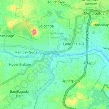
Name: Musi topographic map, elevation, terrain.

Location: Musi, Hyderabad, Telangana, 500028, India (17.36877 78.37910 17.37495 78.44093)

Average elevation: 522 m

Minimum elevation: 491 m

Maximum elevation: 610 m

Other topographic maps

Click on a map to view its topography, its elevation and its terrain.

Ward 132 Jeedimetla

India > Telangana > Hyderabad

Average elevation: 567 m

Hayathnagar mandal

India > Telangana > Hyderabad

Average elevation: 509 m

Hussain Sagar

India > Telangana > Hyderabad

Average elevation: 515 m

Ward 105 Gachibowli

India > Telangana > Hyderabad

Average elevation: 568 m

Gear up for your next adventure:

🧢Thermal Beanie Hats - Prevent heat loss from the head in windy summit conditions
🧥Packable Down Jackets - Lightweight warmth that compresses small in your bag
🕶️Polarized Sunglasses - Reduces glare from snow and water when reading terrain
🧷Tenacious Repair Tape - Instant fix for torn tents, jackets, or dry bags
🧤Thermal Touchscreen Gloves - Stay warm while operating your GPS or smartphone camera

As an Amazon Associate, this site earns from qualifying purchases at no extra cost to you.