Geolocate

Rousay topographic map

Click on the map to display elevation.

About this map

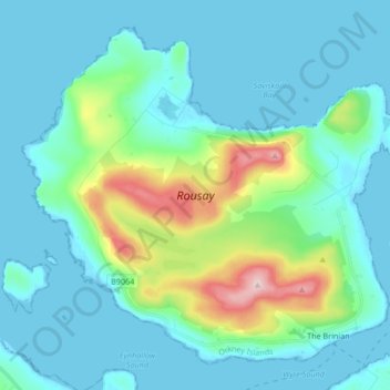
Name: Rousay topographic map, elevation, terrain.

Location: Rousay, The Brinian, Orkney Islands, Scotland, United Kingdom (59.12643 -3.11885 59.19987 -2.95240)

Average elevation: 44 m

Minimum elevation: -1 m

Maximum elevation: 249 m

Orkney Islands trails, hiking, mountain biking, running and outdoor activities

Gear up for your next adventure:

🎿Telescopic Trekking Poles - Reduces knee strain on steep topographic descents
📻Hand-Crank Emergency Radios - Stay updated on weather warnings in remote areas
🥾Women's Waterproof Hiking Boots - High-performance trekking boots designed for all-weather comfort
🧵Survival Paracord - Multi-purpose cordage for emergency repairs and shelters
👟Women's Trail Running Shoes - Agile footwear for fell running and technical trails

As an Amazon Associate, this site earns from qualifying purchases at no extra cost to you.