Geolocate

Tiste topographic map

Interactive map

Click on the map to display elevation.

About this map

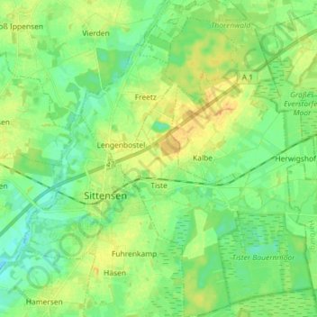
Name: Tiste topographic map, elevation, terrain.

Location: Tiste, Samtgemeinde Sittensen, Landkreis Rotenburg (Wümme), Lower Saxony, Germany (53.25115 9.51138 53.33683 9.60407)

Average elevation: 35 m

Minimum elevation: 24 m

Maximum elevation: 50 m

Other topographic maps

Click on a map to view its topography, its elevation and its terrain.

Beeke

Germany > Lower Saxony > Landkreis Rotenburg (Wümme) > Scheeßel

Beeke, Scheeßel, Landkreis Rotenburg (Wümme), Lower Saxony, Germany

Average elevation: 32 m

Hastenbeck

Germany > Lower Saxony > Landkreis Rotenburg (Wümme) > Deinstedt

Hastenbeck, Deinstedt, Samtgemeinde Selsingen, Landkreis Rotenburg (Wümme), Lower Saxony, Germany

Average elevation: 23 m

Kalbe

Germany > Lower Saxony > Landkreis Rotenburg (Wümme)

Kalbe, Samtgemeinde Sittensen, Landkreis Rotenburg (Wümme), Lower Saxony, Germany

Average elevation: 38 m

Heinrichsdorf

Germany > Lower Saxony > Landkreis Rotenburg (Wümme) > Sandbostel > Heinrichsdorf

Heinrichsdorf, Sandbostel, Samtgemeinde Selsingen, Landkreis Rotenburg (Wümme), Lower Saxony, Germany

Average elevation: 10 m

Abbendorf

Germany > Lower Saxony > Landkreis Rotenburg (Wümme) > Scheeßel > Abbendorf

Abbendorf, Scheeßel, Landkreis Rotenburg (Wümme), Lower Saxony, Germany

Average elevation: 31 m

Hemel

Germany > Lower Saxony > Landkreis Rotenburg (Wümme) > Zeven

Hemel, Zeven, Samtgemeinde Zeven, Landkreis Rotenburg (Wümme), Lower Saxony, Germany

Average elevation: 28 m