Geolocate

Al-Bahah Province topographic map

Interactive map

Click on the map to display elevation.

Al-Bahah Province

The region is divided by huge rocky steeps into two main sectors. To the west is a coastal plain, the Tihamah. To the east is the mountain range of al-As-Sarawat or the Sarat, with an elevation of 1,500 to 2,450 m (4,920 to 8,040 ft) above sea level.

Wikipedia (CC-BY-SA 3.0)

About this map

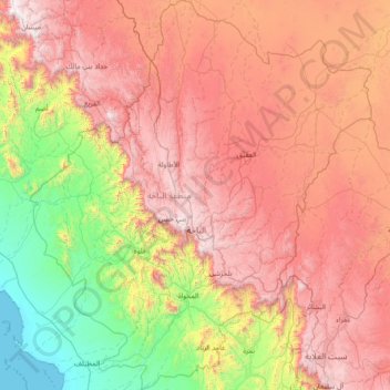
Name: Al-Bahah Province topographic map, elevation, terrain.

Location: Al-Bahah Province, Saudi Arabia (19.44188 40.83591 20.82938 42.13005)

Average elevation: 1,154 m

Minimum elevation: 0 m

Maximum elevation: 2,617 m

Other topographic maps

Click on a map to view its topography, its elevation and its terrain.

Riyadh

Saudi Arabia > Riyadh Region

Riyadh has a hot desert climate (Köppen Climate Classification BWh), with long, extremely hot summers and short, very mild winters. The average high temperature in August is 43.6 °C (110.5 °F). If it was not for the elevation the city was on, Riyadh would experience an even hotter climate. The city…

Average elevation: 630 m

Dammam

Saudi Arabia > Eastern Province

Average elevation: 9 m

Jeddah

Saudi Arabia > Makkah Region

Average elevation: 36 m

Medina

Saudi Arabia > Medina Province

Medina is located in the Hejaz region which is a 200 km (124 mi) wide strip between the Nafud desert and the Red Sea. Located approximately 720 km (447 mi) northwest of Riyadh which is at the center of the Saudi desert, the city is 250 km (155 mi) away from the west coast of Saudi Arabia and at an elevation of…

Average elevation: 692 m

Al Majma'ah

Saudi Arabia > Riyadh Region

Average elevation: 740 m

Turayf

Saudi Arabia > Northern Borders Province

Average elevation: 833 m

Ar Rub` al Khali

Saudi Arabia > Eastern Province > Al Ahsa Governorate

The desert is 1,000 kilometres (620 miles) long, and 500 kilometres (310 miles) wide. Its surface elevation varies from 800 metres (2,600 ft) in the southwest to around sea level in the northeast. Most of the terrain is ergs, with sand dunes up to 250 metres (820 ft) high, interspersed with gravel and gypsum…

Average elevation: 183 m

Al Hani

Saudi Arabia > Riyadh Region

Average elevation: 723 m

Mecca

Saudi Arabia > Makkah Region > Makkah Al Mukarramah > Mecca

Mecca is at an elevation of 277 m (909 ft) above sea level, and approximately 80 km (50 mi) inland from the Red Sea. Central Mecca lies in a corridor between mountains, which is often called the "Hollow of Mecca". The area contains the valley of Al Taneem, the Valley of Bakkah and the valley of Abqar. This…

Average elevation: 313 m

Abha

Saudi Arabia > 'Asir Province

Abha is located in the southern region of Asir at an elevation of about 2,270 metres (7,450 feet) above sea level. Abha lies on the western edge of Mount Al-Hijaz, near Jabal Sawda, the highest peak in Saudi Arabia. Treating the Asir Mountains as part of the Sarawat, the landscape is otherwise dominated by the…

Average elevation: 1,994 m

An Nabiah

Saudi Arabia > Eastern Province

Average elevation: 5 m

Al Jubayl

Saudi Arabia > Eastern Province

Average elevation: 5 m

Dammam

Saudi Arabia > Eastern Province

Average elevation: 9 m

Jizan

Saudi Arabia > Jazan Province

Average elevation: 7 m

Wadi Laban

Saudi Arabia > Riyadh Region

Average elevation: 682 m

An Nabhaniyah

Saudi Arabia > Al-Qassim Province

Average elevation: 754 m

Jabal Sillah

Saudi Arabia > Makkah Region

Average elevation: 60 m

NEOM Community 1

Saudi Arabia > Tabuk Province

Average elevation: 62 m

Al Qadiya

Saudi Arabia > Makkah Region

Average elevation: 572 m

Neom

Saudi Arabia > Neom

Average elevation: 26 m

Sarawat Mountains

Saudi Arabia > Makkah Region

Average elevation: 2,221 m

An Nimas

Saudi Arabia > 'Asir Province

Average elevation: 1,813 m

Al-Hofuf

Saudi Arabia > Eastern Province

Average elevation: 161 m

الشجعة

Saudi Arabia > Jazan Province > Al ddayer

Average elevation: 1,819 m

Hafir Kishb

Saudi Arabia > Makkah Region > Rie Alawali

Average elevation: 990 m

حلبان

Saudi Arabia > 'Asir Province

Average elevation: 878 m

Riyadh

Saudi Arabia > Riyadh Region

Riyadh has a hot desert climate (Köppen Climate Classification BWh), with long, extremely hot summers and short, very mild winters. The average high temperature in July is 43.9 °C (111.0 °F). If not for its elevation Riyadh would experience an even hotter climate. The city experiences very little…

Average elevation: 630 m

العريسة

Saudi Arabia > Najran Region

Average elevation: 1,256 m

Al-'Ula

Saudi Arabia > Al-'Ula

Average elevation: 885 m

Medina

Saudi Arabia > Medina Province

Medina is located in the Hejaz region which is a 200 km (120 mi) wide strip between the Nafud desert and the Red Sea. Located approximately 720 km (450 mi) northwest of Riyadh which is at the center of the Saudi desert, the city is 250 km (160 mi) away from the west coast of Saudi Arabia and at an elevation of…

Average elevation: 692 m

Hawtat Sudayr

Saudi Arabia > Riyadh Region

Average elevation: 727 m

Safwa

Saudi Arabia > Eastern Province

Average elevation: 7 m

Hanish

Saudi Arabia

Average elevation: 0 m

Medina

Saudi Arabia > Medina Province

Medina is located in the Hejaz region which is a 200 km (120 mi) wide strip between the Nafud desert and the Red Sea. Located approximately 720 km (450 mi) northwest of Riyadh which is at the center of the Saudi desert, the city is 250 km (160 mi) away from the west coast of Saudi Arabia and at an elevation of…

Average elevation: 692 m

Kullan

Saudi Arabia > Makkah Region

Average elevation: 976 m

الباب

Saudi Arabia > Makkah Region

Average elevation: 886 m

Tahnan

Saudi Arabia > Jazan Province

Average elevation: 426 m

فَرْدة

Saudi Arabia > Riyadh Region

Average elevation: 896 m

Al Hada

Saudi Arabia > Makkah Region

Average elevation: 1,791 m

Al Qudayh

Saudi Arabia > Eastern Province

Average elevation: 8 m

Tabuk

Saudi Arabia > Tabuk Province

Average elevation: 775 m

Al Jawah

Saudi Arabia > Jazan Province > Fayfa

Average elevation: 983 m

Rabigh Dam

Saudi Arabia > Makkah Region > Rabigh

Average elevation: 187 m

Al Saih

Saudi Arabia > Riyadh Region

Average elevation: 450 m

ابو عريش

Saudi Arabia > Jazan Province > alrrahuh

Average elevation: 200 m

Al Hasamah

Saudi Arabia > Jazan Province

Average elevation: 105 m

Mount Uhud

Saudi Arabia > Medina Province > Sidi Hamzah

Average elevation: 689 m

Riyadh

Saudi Arabia > Riyadh Region

Riyadh has a hot desert climate (Köppen Climate Classification BWh), with long, extremely hot summers and short, very mild winters. The average high temperature in July is 43.9 °C (111.0 °F). If not for its elevation Riyadh would experience an even hotter climate. The city experiences very little…

Average elevation: 630 m

Khamis Mushayt

Saudi Arabia > 'Asir Province

Average elevation: 2,048 m

المشقر

Saudi Arabia > Makkah Region

Average elevation: 1,006 m

وادي ظلم

Saudi Arabia > Medina Province

Average elevation: 809 m

Sabt Al ‘Alayyah

Saudi Arabia > 'Asir Province

Average elevation: 1,678 m

Al Jubayl

Saudi Arabia > Eastern Province

Average elevation: 5 m

mzererat

Saudi Arabia > Ḥa'il Province

Average elevation: 884 m

جبال النير

Saudi Arabia > Riyadh Region > Afif

Average elevation: 1,078 m

الشملي

Saudi Arabia > Ḥa'il Province

Average elevation: 978 m

Thuwal

Saudi Arabia > Makkah Region

Average elevation: 5 m

Rafha

Saudi Arabia > Northern Borders Province

Average elevation: 452 m

Al Qasab

Saudi Arabia > Riyadh Region > Shaqra

Average elevation: 649 m

الرس

Saudi Arabia > 'Asir Province

Average elevation: 2,388 m

Khamis Mushayt

Saudi Arabia > 'Asir Province

Average elevation: 2,048 m

Saihat Lake

Saudi Arabia > Eastern Province > Sayhat

Average elevation: 3 m

King Faisal

Saudi Arabia > Riyadh Region

Average elevation: 613 m

الأنصب

Saudi Arabia > 'Asir Province

Average elevation: 1,367 m

النكاسي

Saudi Arabia > Najran Region

Average elevation: 1,239 m

Abha

Saudi Arabia > 'Asir Province

Abha is located in the southern region of Asir at an elevation of about 2,270 metres (7,450 feet) above sea level. Abha lies on the western edge of Mount Al-Hijaz, near Jabal Sawda, the highest peak in Saudi Arabia. Treating the Asir Mountains as part of the Sarawat, the landscape is otherwise dominated by the…

Average elevation: 1,994 m

الضارب

Saudi Arabia > 'Asir Province > Sarat Abidah

Average elevation: 2,242 m

الردحة

Saudi Arabia > Jazan Province > Baysh

Average elevation: 53 m

قرضة

Saudi Arabia > 'Asir Province

Average elevation: 1,415 m

King Faisal

Saudi Arabia > Riyadh Region

Average elevation: 613 m

Jeddah

Saudi Arabia > Makkah Region

Average elevation: 36 m

Al Hanakiyah

Saudi Arabia > Medina Province

Average elevation: 870 m

Ranyah

Saudi Arabia > Makkah Region

Average elevation: 923 m

وادي الجو

Saudi Arabia > 'Asir Province

Average elevation: 1,352 m

Dhahban

Saudi Arabia > Makkah Region

Average elevation: 20 m

Tabab

Saudi Arabia > 'Asir Province

Average elevation: 1,730 m

Sabt Al ‘Alayyah

Saudi Arabia > 'Asir Province

Average elevation: 1,678 m

Rumah

Saudi Arabia > Riyadh Region

Average elevation: 564 m