Geolocate

Gamping topographic map

Interactive map

Click on the map to display elevation.

About this map

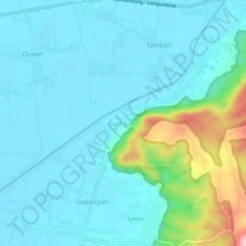
Name: Gamping topographic map, elevation, terrain.

Location: Gamping, Tulungagung, East Java, Java, 66273, Indonesia (-8.20637 111.81185 -8.16637 111.85185)

Average elevation: 113 m

Minimum elevation: 79 m

Maximum elevation: 276 m

Other topographic maps

Click on a map to view its topography, its elevation and its terrain.

Gunung Emas

Indonesia > East Java > Tulungagung > Geger

Average elevation: 1,095 m

Kalidawir

Indonesia > East Java > Tulungagung

Average elevation: 143 m

Gunung Wilis

Indonesia > East Java > Tulungagung

Average elevation: 1,693 m