
Riau topographic map
Interactive map
Click on the map to display elevation.
Riau
In general, the geography of Riau consists of mountains, lowlands, and islands. The mountain area lies in the western part, namely the Bukit Barisan Mountains, near the border of West Sumatra. The elevation decreases towards the east, making most of the central and eastern part of the province covered with lowlands. Off the eastern coast lies the Strait of Malacca where several island lies.
About this map
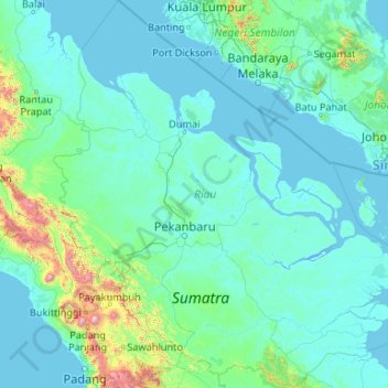
Name: Riau topographic map, elevation, terrain.
Location: Riau, Sumatra, Indonesia (-1.12760 100.02485 3.09058 103.98040)
Average elevation: 115 m
Minimum elevation: -3 m
Maximum elevation: 2,815 m
Other topographic maps
Click on a map to view its topography, its elevation and its terrain.
Tembagapura
Indonesia > Central Papua > Mimika
Tembagapura is situated on a rocky plain at an altitude of 1,930 metres (6,330 ft) at the base of Mount Zaagkam, which lies 16 kilometres (9.9 mi) southeast of the mine. The town is in the Sudirman Range, not far from Puncak Jaya (Mount Carstens), the highest peak in Oceania. The area gets about 3,220…
Average elevation: 2,488 m