Geolocate

Nam-gu topographic map

Interactive map

Click on the map to display elevation.

About this map

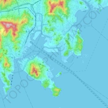
Name: Nam-gu topographic map, elevation, terrain.

Location: Nam-gu, Busan, South Korea (35.04173 129.05390 35.16108 129.21247)

Average elevation: 38 m

Minimum elevation: -5 m

Maximum elevation: 492 m

Other topographic maps

Click on a map to view its topography, its elevation and its terrain.

Haeundae-gu

South Korea > Busan

Average elevation: 51 m

Busanjin-gu

South Korea > Busan

Average elevation: 128 m

Seo-gu

South Korea > Busan

Average elevation: 12 m

Sasang-gu

South Korea > Busan

Average elevation: 113 m

Suyeong-gu

South Korea > Busan

Average elevation: 59 m

Yeonje-gu

South Korea > Busan

Average elevation: 74 m

Saha-gu

South Korea > Busan

Average elevation: 6 m

Gijang-gun

South Korea > Busan

Average elevation: 90 m

Yeongdo-gu

South Korea > Busan

Average elevation: 9 m

Gangseo-gu

South Korea > Busan

Average elevation: 29 m

Geumjeong-gu

South Korea > Busan

Average elevation: 208 m

Samdeok-dong

South Korea > Busan

Average elevation: 25 m