
Make a donation
Gear up for your next adventure:
As an Amazon Associate, this site earns from qualifying purchases at no extra cost to you.
Nairobi topographic map
Click on the map to display elevation.
Make a donation
Gear up for your next adventure:
As an Amazon Associate, this site earns from qualifying purchases at no extra cost to you.
Nairobi
Nairobi was founded in 1899 by colonial authorities in British East Africa, as a rail depot on the Uganda - Kenya Railway. It was favoured by the authorities as an ideal resting place due to its high elevation, temperate climate, and adequate water supply. The town quickly grew to replace Mombasa as the capital of Kenya in 1907.
Make a donation
Gear up for your next adventure:
As an Amazon Associate, this site earns from qualifying purchases at no extra cost to you.
About this map
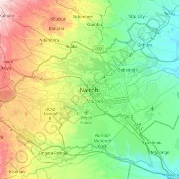
Name: Nairobi topographic map, elevation, terrain.
Average elevation: 1,724 m
Minimum elevation: 1,500 m
Maximum elevation: 2,229 m
Make a donation
Gear up for your next adventure:
As an Amazon Associate, this site earns from qualifying purchases at no extra cost to you.
Other topographic maps
Click on a map to view its topography, its elevation and its terrain.