Geolocate

Caputh topographic map

Click on the map to display elevation.

About this map

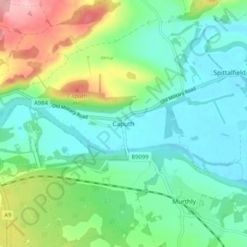
Name: Caputh topographic map, elevation, terrain.

Location: Caputh, Perth and Kinross, Scotland, PH1 4JE, United Kingdom (56.52323 -3.50381 56.56323 -3.46381)

Average elevation: 82 m

Minimum elevation: 32 m

Maximum elevation: 211 m

Perth and Kinross trails, hiking, mountain biking, running and outdoor activities

Gear up for your next adventure:

👟Women's Trail Running Shoes - Agile footwear for fell running and technical trails
🧴Tick Removal Tools - Small, essential health tool for UK woodland and moorland
🖼️Topographic Map Art - Decorative 3D-effect posters of famous UK peaks and regions
🩹Hiking First Aid Kits - Compact medical kits tailored for trail injuries and emergencies
🐕Hiking Dog Harnesses - Rugged harnesses for taking your companion on mountain trails

As an Amazon Associate, this site earns from qualifying purchases at no extra cost to you.