
Thank you for supporting this site ❤️
Make a donation
Make a donation
Gear up for your next adventure:
As an Amazon Associate, this site earns from qualifying purchases at no extra cost to you.
Tamboraque topographic map
Click on the map to display elevation.
Thank you for supporting this site ❤️
Make a donation
Make a donation
Gear up for your next adventure:
As an Amazon Associate, this site earns from qualifying purchases at no extra cost to you.
About this map
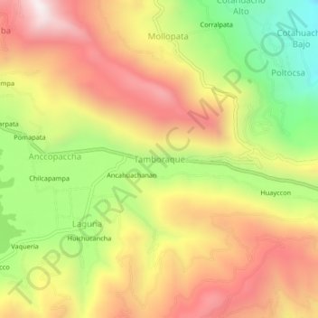
Name: Tamboraque topographic map, elevation, terrain.
Location: Tamboraque, Pacucha, Andahuaylas, Apurímac, 03730, Perú (-13.62594 -73.30450 -13.58594 -73.26450)
Average elevation: 3,242 m
Minimum elevation: 2,714 m
Maximum elevation: 3,704 m
Thank you for supporting this site ❤️
Make a donation
Make a donation
Gear up for your next adventure:
As an Amazon Associate, this site earns from qualifying purchases at no extra cost to you.