
Kiminini topographic map
Interactive map
Click on the map to display elevation.
About this map
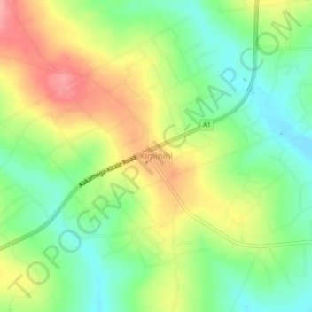
Name: Kiminini topographic map, elevation, terrain.
Location: Kiminini, Trans-Nzoia County, Kenya (0.87259 34.90515 0.91259 34.94515)
Average elevation: 1,754 m
Minimum elevation: 1,711 m
Maximum elevation: 1,808 m
Other topographic maps
Click on a map to view its topography, its elevation and its terrain.
Saboti
Saboti, Trans-Nzoia County, Rift Valley, 30200, Kenya
Average elevation: 2,029 m
Kitale
Kenya > Trans-Nzoia County > Saboti
Kitale, Saboti, Trans-Nzoia County, Rift Valley, Kenya
Average elevation: 1,849 m