
Make a donation
Gear up for your next adventure:
As an Amazon Associate, this site earns from qualifying purchases at no extra cost to you.
Gadwal topographic map
Click on the map to display elevation.
Make a donation
Gear up for your next adventure:
As an Amazon Associate, this site earns from qualifying purchases at no extra cost to you.
Gadwal
Gadwal has an average elevation of 325 metres (1,066 ft). Gadwal's infrastructure includes a railway junction, river, government-owned land, a sub-collector office, national highway connectivity and brand image in the country. It is situated on the southern banks of Krishna river
Make a donation
Gear up for your next adventure:
As an Amazon Associate, this site earns from qualifying purchases at no extra cost to you.
About this map
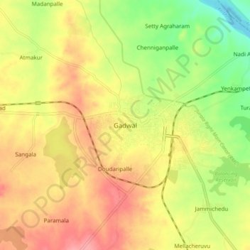
Name: Gadwal topographic map, elevation, terrain.
Average elevation: 323 m
Minimum elevation: 274 m
Maximum elevation: 362 m
Make a donation
Gear up for your next adventure:
As an Amazon Associate, this site earns from qualifying purchases at no extra cost to you.