
La Jacourelle topographic map
Interactive map
Click on the map to display elevation.
About this map
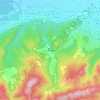
Name: La Jacourelle topographic map, elevation, terrain.
Average elevation: 258 m
Minimum elevation: 129 m
Maximum elevation: 479 m
Other topographic maps
Click on a map to view its topography, its elevation and its terrain.
Village Vacances de La Baume
France > Provence-Alpes-Côte d'Azur > Bouches-du-Rhône > La Roque-d'Anthéron
Village Vacances de La Baume, La Roque-d'Anthéron, Aix-en-Provence, Bouches-du-Rhône, Provence-Alpes-Côte d'Azur, France métropolitaine, 13640, France
Average elevation: 225 m
Bassin de Saint-Christophe
France > Provence-Alpes-Côte d'Azur > Bouches-du-Rhône > La Roque-d'Anthéron
Bassin de Saint-Christophe, La Roque-d'Anthéron, Aix-en-Provence, Bouches-du-Rhône, Provence-Alpes-Côte d'Azur, France métropolitaine, 13840, France
Average elevation: 202 m