
Make a donation
Gear up for your next adventure:
As an Amazon Associate, this site earns from qualifying purchases at no extra cost to you.
Sarnia topographic map
Click on the map to display elevation.
Make a donation
Gear up for your next adventure:
As an Amazon Associate, this site earns from qualifying purchases at no extra cost to you.
Sarnia
Sarnia is located on the eastern shore of Lake Huron at its extreme southern point, where it flows into the St. Clair River. Most of the surrounding area is flat, and the elevation ranges from 169 to 281 m (554 to 922 ft) above sea level. The soil mainly comprises clay. Despite this high percentage of clay, the soil is remarkably rich for cultivation.
Make a donation
Gear up for your next adventure:
As an Amazon Associate, this site earns from qualifying purchases at no extra cost to you.
About this map
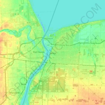
Name: Sarnia topographic map, elevation, terrain.
Location: Sarnia, Lambton County, Ontario, Canada (42.91182 -82.46010 43.03856 -82.22987)
Average elevation: 186 m
Minimum elevation: 173 m
Maximum elevation: 202 m
Make a donation
Gear up for your next adventure:
As an Amazon Associate, this site earns from qualifying purchases at no extra cost to you.