
Waltham topographic map
Interactive map
Click on the map to display elevation.
About this map
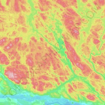
Name: Waltham topographic map, elevation, terrain.
Location: Waltham, Pontiac, Outaouais, Quebec, J0X 3H0, Canada (45.89225 -77.04870 46.16432 -76.79797)
Average elevation: 245 m
Minimum elevation: 104 m
Maximum elevation: 409 m
Its territory, with a maximum elevation of just over 350 metres (1,150 ft), is sparsely populated, the majority of the population living along or near the Ottawa River. The northern portion is a vast extended tract of undeveloped land, dotted with lakes, such as Findlay, Landon, Gagnon, and Caughlin, which are popular for fishing.
Other topographic maps
Click on a map to view its topography, its elevation and its terrain.
Greer Mount
Canada > Quebec > Pontiac > Thorne
Greer Mount, Thorne, Pontiac, Outaouais, Quebec, Canada
Average elevation: 261 m
Lac Rueckwald
Canada > Quebec > Pontiac > Thorne
Lac Rueckwald, Thorne, Pontiac, Outaouais, Quebec, Canada
Average elevation: 223 m
Bristol Mines
Canada > Quebec > Pontiac > Bristol
Bristol Mines, Bristol, Pontiac, Outaouais, Quebec, J0X 1G0, Canada
Average elevation: 93 m
Lac Sopwith
Canada > Quebec > Pontiac > Otter Lake
Lac Sopwith, Otter Lake, Pontiac, Outaouais, Quebec, Canada
Average elevation: 275 m
L'Isle-aux-Allumettes
L'Isle-aux-Allumettes, Pontiac, Outaouais, Quebec, Canada
Average elevation: 148 m
Lac Antiquois
Canada > Quebec > Pontiac > Lac-Nilgaut
Lac Antiquois, Lac-Nilgaut, Pontiac, Outaouais, Quebec, Canada
Average elevation: 366 m
Otter Lake
Otter Lake, Pontiac, Outaouais, Quebec, J0X 2P0, Canada
Average elevation: 262 m
Danford Lake
Canada > Quebec > Pontiac > Alleyn-et-Cawood
Danford Lake, Alleyn-et-Cawood, Pontiac, Outaouais, Quebec, J0X 1P0, Canada
Average elevation: 210 m