
Kent topographic map
Interactive map
Click on the map to display elevation.
About this map
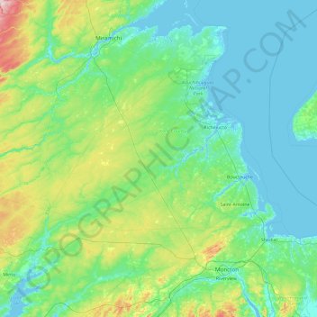
Name: Kent topographic map, elevation, terrain.
Location: Kent, Kent County, Nuevo Brunswick, Canadá (45.90252 -65.83952 47.18252 -64.55952)
Average elevation: 52 m
Minimum elevation: -4 m
Maximum elevation: 365 m
Other topographic maps
Click on a map to view its topography, its elevation and its terrain.
Saint-Isidore Parish
Canadá > Nuevo Brunswick > Gloucester County
Saint-Isidore Parish, Gloucester County, Nuevo Brunswick, Canadá
Average elevation: 48 m
Westmoreland
Westmoreland, Westmorland County, Nuevo Brunswick, E1H 1N8, Canadá
Average elevation: 63 m