
El Guayabal topographic map
Interactive map
Click on the map to display elevation.
About this map
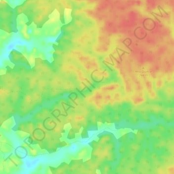
Name: El Guayabal topographic map, elevation, terrain.
Location: El Guayabal, Solano, Caquetá, Colombia (0.83560 -75.10832 0.86040 -75.05978)
Average elevation: 245 m
Minimum elevation: 214 m
Maximum elevation: 271 m
Other topographic maps
Click on a map to view its topography, its elevation and its terrain.
Cartagena del Chairá
Cartagena del Chairá, Caquetá, RAP Amazonía, Colombia
Average elevation: 240 m
Chiribiquete (Macizo Central)
Chiribiquete (Macizo Central), Solano, Caquetá, Colombia
Average elevation: 290 m
Azabache
Colombia > Caquetá > Belén de los Andaquíes
Azabache, Belén de los Andaquíes, Caquetá, Colombia
Average elevation: 253 m
San Vicente del Caguán
San Vicente del Caguán, Caquetá, 182010, Colombia
Average elevation: 585 m
Puerto Gaitan
Colombia > Caquetá > Puerto Gaitan
Puerto Gaitan, La Montañita, Caquetá, Colombia
Average elevation: 249 m
San Vicente del Caguán
Colombia > Caquetá > San Vicente del Caguán > San Vicente del Caguán
San Vicente del Caguán, Caquetá, 182010, Colombia
Average elevation: 276 m