
Булункул topographic map
Interactive map
Click on the map to display elevation.
About this map
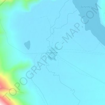
Name: Булункул topographic map, elevation, terrain.
Average elevation: 3,775 m
Minimum elevation: 3,738 m
Maximum elevation: 4,200 m
Other topographic maps
Click on a map to view its topography, its elevation and its terrain.
Памир
Tadschikistan > Autonome Provinz Berg-Badachschan > Bezirk Murghob
Памир, Bezirk Murghob, Autonome Provinz Berg-Badachschan, Tadschikistan
Average elevation: 6,355 m
Маркансу
Tadschikistan > Autonome Provinz Berg-Badachschan > Bezirk Murghob
Маркансу, Bezirk Murghob, Autonome Provinz Berg-Badachschan, Tadschikistan
Average elevation: 4,313 m
Pik Lenin
Tadschikistan > Autonome Provinz Berg-Badachschan > Bezirk Murghob
Pik Lenin, Bezirk Murghob, Autonome Provinz Berg-Badachschan, Tadschikistan
Average elevation: 6,564 m
Харгуш
Tadschikistan > Autonome Provinz Berg-Badachschan > Bezirk Murghob
Харгуш, Bezirk Murghob, Autonome Provinz Berg-Badachschan, Tadschikistan
Average elevation: 3,991 m
Murghab
Tadschikistan > Autonome Provinz Berg-Badachschan > Bezirk Murghob
Murghab, Bezirk Murghob, Autonome Provinz Berg-Badachschan, 736600, Tadschikistan
Average elevation: 3,797 m