
Make a donation
Gear up for your next adventure:
As an Amazon Associate, this site earns from qualifying purchases at no extra cost to you.
Cayote topographic map
Click on the map to display elevation.
Make a donation
Gear up for your next adventure:
As an Amazon Associate, this site earns from qualifying purchases at no extra cost to you.
About this map
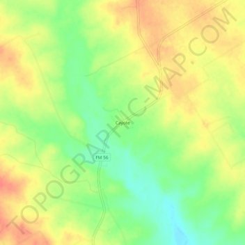
Name: Cayote topographic map, elevation, terrain.
Location: Cayote, Bosque County, Texas, United States (31.74877 -97.47752 31.78877 -97.43752)
Average elevation: 225 m
Minimum elevation: 196 m
Maximum elevation: 248 m
Make a donation
Gear up for your next adventure:
As an Amazon Associate, this site earns from qualifying purchases at no extra cost to you.
Other topographic maps
Click on a map to view its topography, its elevation and its terrain.
Valley Mills
United States > Texas > Bosque County
The airport covers 90 acres (36 ha) at an elevation of 751 feet (229 m) above mean sea level (AMSL), and has two runways.
Average elevation: 191 m
Make a donation
Gear up for your next adventure:
As an Amazon Associate, this site earns from qualifying purchases at no extra cost to you.