
Amareleja topographic map
Interactive map
Click on the map to display elevation.
About this map
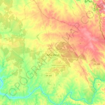
Name: Amareleja topographic map, elevation, terrain.
Location: Amareleja, Moura, Beja, Portugal (38.13805 -7.29335 38.28182 -7.15203)
Average elevation: 198 m
Minimum elevation: 101 m
Maximum elevation: 305 m
Other topographic maps
Click on a map to view its topography, its elevation and its terrain.
Moura (Santo Agostinho e São João Batista) e Santo Amador
Moura (Santo Agostinho e São João Batista) e Santo Amador, Moura, Beja, Portugal
Average elevation: 184 m
Descarga de Superficie
Descarga de Superficie, Moura (Santo Agostinho e São João Batista) e Santo Amador, Moura, Beja, 7830-286, Portugal
Average elevation: 227 m