
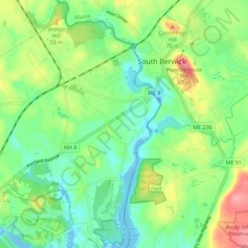
Rollinsford topographic map
Interactive map
Click on the map to display elevation.
About this map
Name: Rollinsford topographic map, elevation, terrain.
Average elevation: 32 m
Minimum elevation: -9 m
Maximum elevation: 90 m
Other topographic maps
Click on a map to view its topography, its elevation and its terrain.
Somersworth
United States > New Hampshire > Strafford County
According to the United States Census Bureau, the city has a total area of 10.0 square miles (25.9 km2), of which 9.8 square miles (25.4 km2) are land and 0.2 square miles (0.5 km2) are water, comprising 1.96% of the city. Somersworth is bordered to the northeast by the Salmon Falls River, which is also the…
Average elevation: 56 m
Dover
United States > New Hampshire > Strafford County
According to the United States Census Bureau, the city has a total area of 29.0 square miles (75.2 km2), of which 26.7 square miles (69.2 km2) are land and 2.3 square miles (6.0 km2) are water, comprising 7.97% of the city. Dover is drained by the Cochecho and Bellamy rivers, both of which flow into the tidal…
Average elevation: 31 m