
Hoogstede topographic map
Interactive map
Click on the map to display elevation.
About this map
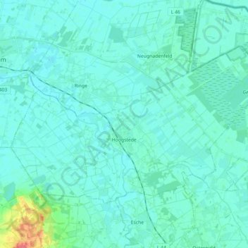
Name: Hoogstede topographic map, elevation, terrain.
Average elevation: 18 m
Minimum elevation: 11 m
Maximum elevation: 66 m
Other topographic maps
Click on a map to view its topography, its elevation and its terrain.
Schüttorf
Germany > Lower Saxony > Landkreis Grafschaft Bentheim
The town of Schüttorf lies mainly on valley sand plates which are crossed by the Vechte Lowland, which is almost flush with them along this stretch. The lowland lies roughly 30 m above sea level and is from 200 to 500 m wide. Bordering its edges are river terraces with a height of roughly 35 m above sea…
Average elevation: 39 m