
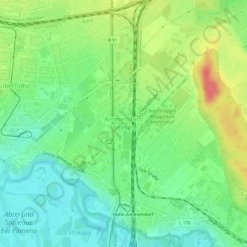
Ammendorf/Beesen topographic map
Interactive map
Click on the map to display elevation.
About this map
Name: Ammendorf/Beesen topographic map, elevation, terrain.
Average elevation: 99 m
Minimum elevation: 76 m
Maximum elevation: 134 m
Other topographic maps
Click on a map to view its topography, its elevation and its terrain.
Heide-Süd
Deutschland > Sachsen-Anhalt > Halle (Saale)
Heide-Süd, Halle (Saale), Sachsen-Anhalt, Deutschland
Average elevation: 92 m
Gottfried-Keller-Siedlung
Deutschland > Sachsen-Anhalt > Halle (Saale)
Gottfried-Keller-Siedlung, Halle (Saale), Sachsen-Anhalt, 06118, Deutschland
Average elevation: 106 m
Reideburg
Deutschland > Sachsen-Anhalt > Halle (Saale)
Reideburg, Halle (Saale), Sachsen-Anhalt, Deutschland
Average elevation: 98 m
Kanena
Deutschland > Sachsen-Anhalt > Halle (Saale) > Kanena
Kanena, Halle (Saale), Sachsen-Anhalt, 06116, Deutschland
Average elevation: 97 m
Diemitz
Deutschland > Sachsen-Anhalt > Halle (Saale)
Diemitz, Halle (Saale), Sachsen-Anhalt, Deutschland
Average elevation: 109 m
Nördliche Innenstadt
Deutschland > Sachsen-Anhalt > Halle (Saale)
Nördliche Innenstadt, Halle (Saale), Sachsen-Anhalt, Deutschland
Average elevation: 97 m
Paulusviertel
Deutschland > Sachsen-Anhalt > Halle (Saale)
Paulusviertel, Halle (Saale), Sachsen-Anhalt, 06114, Deutschland
Average elevation: 106 m