
Make a donation
Gear up for your next adventure:
As an Amazon Associate, this site earns from qualifying purchases at no extra cost to you.
Recetto topographic map
Click on the map to display elevation.
Make a donation
Gear up for your next adventure:
As an Amazon Associate, this site earns from qualifying purchases at no extra cost to you.
About this map
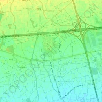
Name: Recetto topographic map, elevation, terrain.
Location: Recetto, Novara, Piemonte, 28960, Italia (45.44271 8.39973 45.47307 8.45058)
Average elevation: 163 m
Minimum elevation: 152 m
Maximum elevation: 176 m
Make a donation
Gear up for your next adventure:
As an Amazon Associate, this site earns from qualifying purchases at no extra cost to you.
Other topographic maps
Click on a map to view its topography, its elevation and its terrain.
Make a donation
Gear up for your next adventure:
As an Amazon Associate, this site earns from qualifying purchases at no extra cost to you.
Riserva Naturale Speciale del Sacro Monte di Orta
Italia > Piemonte > Novara > Orta San Giulio > Legro
Average elevation: 332 m