Jongno-gu topographic map
Click on the map to display elevation.
Jongno-gu
Jongno was historically the center of Joseon and, later, the Korean Empire. It retained its prominence in the modern era after the establishment of South Korea. Hanyang, the capital of Joseon, included Jongno and the Jung District. In October 1394, King Taejo moved his capital from Gaegyeong to Hanyang. The capital of Goryeo, Gaegyeong, had a strong base of traditional forces against King Taejo. In addition, the topography divination theory states that the new dynasty was unlucky due to its failure, and that it also moved to Hanyang with regard to water transport of rice and military geographical conditions. Following the relocation of the capital city, the Joseon government pushed for the construction of Hanyang, starting with the construction of Jongmyo, Gyeongbokgung, and Changdeokgung. In 1395, it was renamed as Hanyang Department. In 1399, the first year of King Jeongjong's reign, the capital was moved to Gagyeong as a result of the Prince's rebellion. In 1405, the fifth year of King Taejong's reign, the capital was changed back to Hanyang. By King Sejong's time, the city grew into a large city with about 200,000 people.
About this map
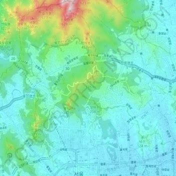
Name: Jongno-gu topographic map, elevation, terrain.
Location: Jongno-gu, Seoul, South Korea (37.56580 126.94890 37.63235 127.02342)
Average elevation: 143 m
Minimum elevation: 20 m
Maximum elevation: 698 m
Other topographic maps
Click on a map to view its topography, its elevation and its terrain.