
Sargenroth topographic map
Interactive map
Click on the map to display elevation.
About this map
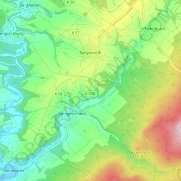
Name: Sargenroth topographic map, elevation, terrain.
Average elevation: 393 m
Minimum elevation: 282 m
Maximum elevation: 598 m
The municipality lies in the central Hunsrück, between the Simmerbach valley and the Soonwald, a heavily wooded section of the west-central Hunsrück, roughly 8 km east of Kirchberg and 5 km south of Simmern. Sargenroth's highest elevation is the Wildburghöhe, 629 m above sea level.
Other topographic maps
Click on a map to view its topography, its elevation and its terrain.
Rheinböllen
Germany > Rhineland-Palatinate > Rhein-Hunsrück-Kreis
Rheinböllen, Simmern-Rheinböllen, Rhein-Hunsrück-Kreis, Rhineland-Palatinate, 55494, Germany
Average elevation: 452 m
Damscheid
Germany > Rhineland-Palatinate > Rhein-Hunsrück-Kreis
Damscheid, Hunsrück-Mittelrhein, Rhein-Hunsrück-Kreis, Rhineland-Palatinate, Germany
Average elevation: 348 m
Bärenbach
Germany > Rhineland-Palatinate > Rhein-Hunsrück-Kreis
Bärenbach, Kirchberg (Hunsrück), Rhein-Hunsrück-Kreis, Rhineland-Palatinate, Germany
Average elevation: 457 m
Tiefenbach
Germany > Rhineland-Palatinate > Rhein-Hunsrück-Kreis
Tiefenbach, Simmern-Rheinböllen, Rhein-Hunsrück-Kreis, Rhineland-Palatinate, Germany
Average elevation: 418 m
Sankt Goar
Germany > Rhineland-Palatinate > Rhein-Hunsrück-Kreis
Sankt Goar, Hunsrück-Mittelrhein, Rhein-Hunsrück-Kreis, Rhineland-Palatinate, Germany
Average elevation: 232 m
Horn
Germany > Rhineland-Palatinate > Rhein-Hunsrück-Kreis
Horn, Simmern-Rheinböllen, Rhein-Hunsrück-Kreis, Rhineland-Palatinate, Germany
Average elevation: 449 m
Laubach
Germany > Rhineland-Palatinate > Rhein-Hunsrück-Kreis
Laubach, Simmern-Rheinböllen, Rhein-Hunsrück-Kreis, Rhineland-Palatinate, Germany
Average elevation: 458 m
Oberwesel
Germany > Rhineland-Palatinate > Rhein-Hunsrück-Kreis
Oberwesel, Hunsrück-Mittelrhein, Rhein-Hunsrück-Kreis, Rhineland-Palatinate, 55430, Germany
Average elevation: 276 m
Belg
Germany > Rhineland-Palatinate > Rhein-Hunsrück-Kreis
Belg, Kirchberg (Hunsrück), Rhein-Hunsrück-Kreis, Rhineland-Palatinate, Germany
Average elevation: 426 m