
Thank you for supporting this site ❤️
Make a donation
Make a donation
Gear up for your next adventure:
As an Amazon Associate, this site earns from qualifying purchases at no extra cost to you.
Vallenar topographic map
Click on the map to display elevation.
Thank you for supporting this site ❤️
Make a donation
Make a donation
Gear up for your next adventure:
As an Amazon Associate, this site earns from qualifying purchases at no extra cost to you.
About this map
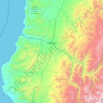
Name: Vallenar topographic map, elevation, terrain.
Location: Vallenar, Provincia de Huasco, Atacama Region, Chile (-29.35604 -71.19931 -28.00986 -70.00347)
Average elevation: 1,328 m
Minimum elevation: 0 m
Maximum elevation: 5,545 m
Thank you for supporting this site ❤️
Make a donation
Make a donation
Gear up for your next adventure:
As an Amazon Associate, this site earns from qualifying purchases at no extra cost to you.