
Make a donation
Gear up for your next adventure:
As an Amazon Associate, this site earns from qualifying purchases at no extra cost to you.
Busua topographic map
Click on the map to display elevation.
Make a donation
Gear up for your next adventure:
As an Amazon Associate, this site earns from qualifying purchases at no extra cost to you.
About this map
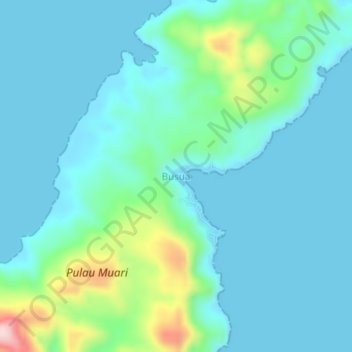
Name: Busua topographic map, elevation, terrain.
Location: Busua, Halmahera Selatan, North Maluku, Indonesia (-0.22453 127.10627 -0.18453 127.14627)
Average elevation: 49 m
Minimum elevation: 0 m
Maximum elevation: 278 m
Make a donation
Gear up for your next adventure:
As an Amazon Associate, this site earns from qualifying purchases at no extra cost to you.
Other topographic maps
Click on a map to view its topography, its elevation and its terrain.
Makian Island
Indonesia > North Maluku > Halmahera Selatan > Matsa (matan Tengin)
Average elevation: 246 m
Make a donation
Gear up for your next adventure:
As an Amazon Associate, this site earns from qualifying purchases at no extra cost to you.