
Vichy topographic map
Interactive map
Click on the map to display elevation.
About this map
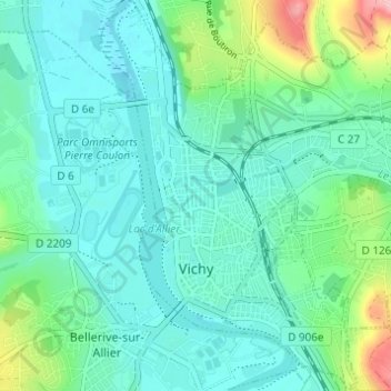
Name: Vichy topographic map, elevation, terrain.
Average elevation: 276 m
Minimum elevation: 243 m
Maximum elevation: 399 m
Other topographic maps
Click on a map to view its topography, its elevation and its terrain.
Demon
Frankreich > Auvergne-Rhone-Alpen > Allier > Le Mayet-de-Montagne
Demon, Le Mayet-de-Montagne, Vichy, Allier, Auvergne-Rhone-Alpen, Metropolitanes Frankreich, 03250, Frankreich
Average elevation: 513 m
Montluçon
Frankreich > Auvergne-Rhone-Alpen > Allier > Montluçon
Montluçon, Allier, Auvergne-Rhone-Alpen, Metropolitanes Frankreich, 03100, Frankreich
Average elevation: 256 m