Geolocate

Ponyri topographic map

Click on the map to display elevation.

About this map
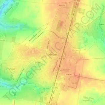
Name: Ponyri topographic map, elevation, terrain.

Location: Ponyri, Ponyrovsky District, Kursk Oblast, Central Federal District, 306000, Russia (52.30224 36.27289 52.33752 36.32131)

Average elevation: 243 m

Minimum elevation: 217 m

Maximum elevation: 256 m

Other topographic maps

Click on a map to view its topography, its elevation and its terrain.
Снава

Russia > Kursk Oblast > Ponyrovsky District

Average elevation: 230 m

Снава

Russia > Kursk Oblast > Ponyrovsky District

Average elevation: 230 m

Gear up for your next adventure:

🪢Paracord - Multi-purpose cord for camping and survival
🗺️Scratch-off Peak Maps - Track your progress climbing Munros or Wainwrights
👟Waterproof Leg Gaiters - Keep mud and water out of your boots in boggy terrain
🧣Neck Gaiters - Protects against wind and sun on exposed ridges and peaks
🧢Waterproof Hiking Hats - Keep the rain off your face while studying topographic maps

As an Amazon Associate, this site earns from qualifying purchases at no extra cost to you.