
Gilbert topographic map
Click on the map to display elevation.
About this map
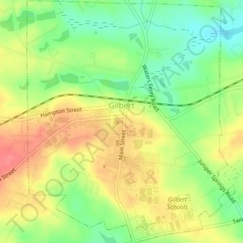
Name: Gilbert topographic map, elevation, terrain.
Location: Gilbert, Lexington County, South Carolina, United States (33.90858 -81.40675 33.93625 -81.37808)
Average elevation: 164 m
Minimum elevation: 130 m
Maximum elevation: 198 m
Other topographic maps
Click on a map to view its topography, its elevation and its terrain.
Batesburg
United States > South Carolina > Lexington County > Batesburg-Leesville
Average elevation: 186 m
Leesville
United States > South Carolina > Lexington County > Batesburg-Leesville
Average elevation: 190 m
Leesville
United States > South Carolina > Lexington County > Batesburg-Leesville > Leesville
Average elevation: 190 m