Geolocate

Souillac topographic map

Click on the map to display elevation.

About this map
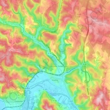
Name: Souillac topographic map, elevation, terrain.

Location: Souillac, Gourdon, Lot, Occitania, Metropolitan France, 46200, France (44.87865 1.41074 44.95328 1.52220)

Average elevation: 205 m

Minimum elevation: 82 m

Maximum elevation: 326 m

Other topographic maps

Click on a map to view its topography, its elevation and its terrain.

Flaujac-Haut

France > Occitania > Lot > Flaujac-Gare

Average elevation: 335 m

Bovila

France > Occitania > Lot > Porte-du-Quercy

Average elevation: 243 m

Labrousse

France > Occitania > Lot > Prayssac

Average elevation: 123 m

Mas Ponchet

France > Occitania > Lot > Cressensac-Sarrazac

Average elevation: 215 m

Les Vignottes

France > Occitania > Lot > Prendeignes

Average elevation: 373 m

Cournou

France > Occitania > Lot > Saint-Vincent-Rive-d'Olt

Average elevation: 243 m

Revers

France > Occitania > Lot > Le Vigan-en-Quercy

Average elevation: 262 m

Brugales

France > Occitania > Lot > Laval-de-Cère

Average elevation: 311 m

Saint-Esprit

France > Occitania > Lot > Martel

Average elevation: 239 m

Concots

France > Occitania > Lot > Concots > Concots

Average elevation: 268 m

Les Boules

France > Occitania > Lot > Bellefont-La Rauze

Average elevation: 276 m

Gear up for your next adventure:

🗺️Ordnance Survey Maps - Essential paper maps for hiking across the UK national parks
🧢Waterproof Hiking Hats - Keep the rain off your face while studying topographic maps
🧣Neck Gaiters - Protects against wind and sun on exposed ridges and peaks
🍳Camping Stoves - Compact stoves for outdoor cooking
🔋Lithium AA Batteries - Long-lasting power that performs well in cold mountain weather

As an Amazon Associate, this site earns from qualifying purchases at no extra cost to you.