
Au Moulin topographic map
Interactive map
Click on the map to display elevation.
About this map
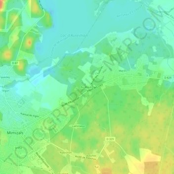
Name: Au Moulin topographic map, elevation, terrain.
Average elevation: 16 m
Minimum elevation: 1 m
Maximum elevation: 39 m
Other topographic maps
Click on a map to view its topography, its elevation and its terrain.
Mares
France > Nouvelle-Aquitaine > Landes > Aureilhan
Mares, Aureilhan, Mont-de-Marsan, Landes, Nouvelle-Aquitaine, France métropolitaine, 40200, France
Average elevation: 15 m