Ishpeming topographic map
Click on the map to display elevation.
Ishpeming
Ishpeming is in central Marquette County, 15 miles (24 km) west of Marquette, the county seat. It is bordered to the east by the city of Negaunee. According to the United States Census Bureau, Ishpeming has a total area of 9.35 square miles (24.22 km2), of which 8.74 square miles (22.64 km2) are land and 0.61 square miles (1.58 km2), or 6.50%, are water. Ishpeming's elevation is 1,436 feet (438 m) above mean sea level, which is over 800 feet (240 m) higher than that of nearby Lake Superior. The highlands of Ishpeming and the surrounding area, including the city of Negaunee to its east, receive an unusually high yearly average of lake-effect snow.
About this map
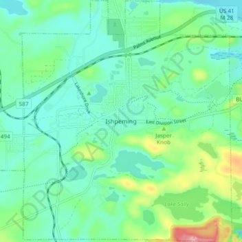
Name: Ishpeming topographic map, elevation, terrain.
Location: Ishpeming, Marquette County, Michigan, United States (46.46306 -87.69786 46.51389 -87.63378)
Average elevation: 449 m
Minimum elevation: 411 m
Maximum elevation: 569 m
Other topographic maps
Click on a map to view its topography, its elevation and its terrain.
Van Riper State Park
United States > Michigan > Marquette County > Michigamme Township
Average elevation: 489 m

Horseshoe Lake
United States > Michigan > Marquette County > Republic Township
Average elevation: 503 m
Skinnies Lake
United States > Michigan > Marquette County > Humboldt Township
Average elevation: 453 m