
Make a donation
Gear up for your next adventure:
As an Amazon Associate, this site earns from qualifying purchases at no extra cost to you.
Kandukur topographic map
Click on the map to display elevation.
Make a donation
Gear up for your next adventure:
As an Amazon Associate, this site earns from qualifying purchases at no extra cost to you.
About this map
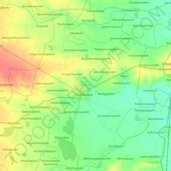
Name: Kandukur topographic map, elevation, terrain.
Average elevation: 20 m
Minimum elevation: 1 m
Maximum elevation: 49 m
Make a donation
Gear up for your next adventure:
As an Amazon Associate, this site earns from qualifying purchases at no extra cost to you.
Other topographic maps
Click on a map to view its topography, its elevation and its terrain.
Kandukur
India > Andhra Pradesh > Kandukur
Kandukuru (earlier known as Skandapuri) is located at 15°12′59″N 79°54′15″E / 15.2165°N 79.9042°E / 15.2165; 79.9042. It has an average elevation of 13 metres (43 ft). Kandukur was a part of the erstwhile Nellore district and was then included in the newly carved out Prakasam District in…
Average elevation: 18 m