Geolocate

Kallayi topographic map

Click on the map to display elevation.

About this map

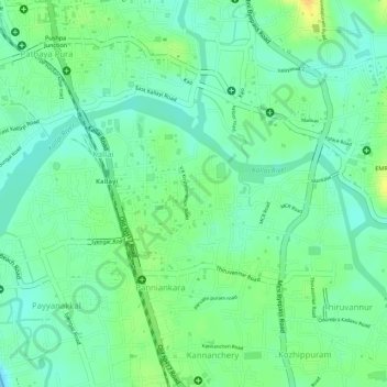
Name: Kallayi topographic map, elevation, terrain.

Location: Kallayi, Kallai, Kozhikode, Kerala, 673003, India (11.22757 75.78584 11.23706 75.80300)

Average elevation: 13 m

Minimum elevation: 0 m

Maximum elevation: 30 m

Other topographic maps

Click on a map to view its topography, its elevation and its terrain.

Kuttichira

India > Kerala > Kozhikode > Kozhikode

Average elevation: 8 m

Mananchira

India > Kerala > Kozhikode > Kozhikode

Average elevation: 12 m

Gear up for your next adventure:

🧴Tick Removal Tools - Small, essential health tool for UK woodland and moorland
🔦LED Camping Lanterns - Illumination for reading maps inside your tent at night
📦Compression Sacks - Reduce backpack volume efficiently
📻Hand-Crank Emergency Radios - Stay updated on weather warnings in remote areas
🚲Bikepacking Frame Bags - Storage for tools and navigation gear on long off-road rides

As an Amazon Associate, this site earns from qualifying purchases at no extra cost to you.