
Thank you for supporting this site ❤️
Make a donation
Make a donation
Gear up for your next adventure:
As an Amazon Associate, this site earns from qualifying purchases at no extra cost to you.
Iona topographic map
Click on the map to display elevation.
Thank you for supporting this site ❤️
Make a donation
Make a donation
Gear up for your next adventure:
As an Amazon Associate, this site earns from qualifying purchases at no extra cost to you.
About this map
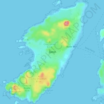
Name: Iona topographic map, elevation, terrain.
Location: Iona, The Village, Argyll and Bute, Scotland, United Kingdom (56.30670 -6.44491 56.35095 -6.38138)
Average elevation: 9 m
Minimum elevation: -1 m
Maximum elevation: 96 m
Argyll and Bute trails, hiking, mountain biking, running and outdoor activities
Thank you for supporting this site ❤️
Make a donation
Make a donation
Gear up for your next adventure:
As an Amazon Associate, this site earns from qualifying purchases at no extra cost to you.