
Make a donation
Gear up for your next adventure:
As an Amazon Associate, this site earns from qualifying purchases at no extra cost to you.
El Mazo topographic map
Click on the map to display elevation.
Make a donation
Gear up for your next adventure:
As an Amazon Associate, this site earns from qualifying purchases at no extra cost to you.
About this map
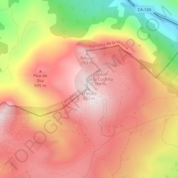
Name: El Mazo topographic map, elevation, terrain.
Location: El Mazo, Valle de Carranza, Vizcaya, País Vasco, 48895, España (43.24399 -3.41284 43.24409 -3.41274)
Average elevation: 546 m
Minimum elevation: 98 m
Maximum elevation: 808 m
Make a donation
Gear up for your next adventure:
As an Amazon Associate, this site earns from qualifying purchases at no extra cost to you.
Other topographic maps
Click on a map to view its topography, its elevation and its terrain.
Parque Natural de Armañón
España > País Vasco > Valle de Carranza
En 2022 se realizó una excavación arqueológica que dirigió Juan Carlos López Quintana en la cual se determinó su singularidad dentro del Megalitismo cantábrico-oriental y se pudieron observar e identifican dos fases constructivas, con técnicas y materiales diferentes, realizadas en un corto plaza entre…
Average elevation: 376 m