
Cedartown topographic map
Interactive map
Click on the map to display elevation.
About this map
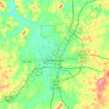
Name: Cedartown topographic map, elevation, terrain.
Location: Cedartown, Polk County, Georgia, 30125, United States (33.96199 -85.29953 34.07512 -85.16750)
Average elevation: 260 m
Minimum elevation: 219 m
Maximum elevation: 336 m
Other topographic maps
Click on a map to view its topography, its elevation and its terrain.
Vance Lake
United States > Georgia > Polk County > Cedartown
Vance Lake, Cedartown, Polk County, Georgia, United States
Average elevation: 244 m
Aragon
United States > Georgia > Polk County
Aragon, Polk County, Georgia, United States
Average elevation: 231 m