
Kapan topographic map
Interactive map
Click on the map to display elevation.
About this map
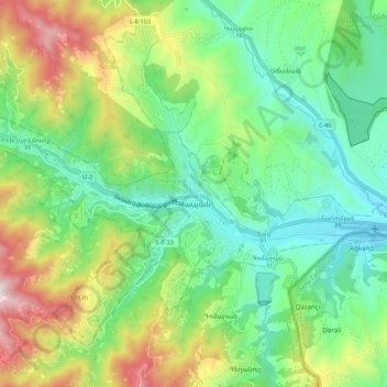
Name: Kapan topographic map, elevation, terrain.
Location: Kapan, Kapan Community, Syunik Province, Armenia (39.19318 46.34024 39.22627 46.44828)
Average elevation: 1,026 m
Minimum elevation: 693 m
Maximum elevation: 1,711 m
The town is about 80 km (50 mi) north of the Iranian border. With a height of 3201 meters, Mount Khustup is the highest peak of the region. The elevation of Kapan is 750–1050 meters above sea level, with an average height of 910 meters. Two tributaries of the Voghji River, Vachagan and Kavart, flow through the town.
Other topographic maps
Click on a map to view its topography, its elevation and its terrain.
Kapan
Armenia > Syunik Province > Kapan
Kapan, Syunik Province, 3304, Armenia
Average elevation: 1,021 m