
gmina Morąg topographic map
Interactive map
Click on the map to display elevation.
About this map
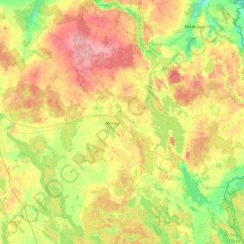
Name: gmina Morąg topographic map, elevation, terrain.
Average elevation: 119 m
Minimum elevation: 58 m
Maximum elevation: 190 m
Other topographic maps
Click on a map to view its topography, its elevation and its terrain.
Schönaich
Polen > Woiwodschaft Ermland-Masuren > powiat ostródzki
Schönaich, Gemeinde Liebemühl, powiat ostródzki, Woiwodschaft Ermland-Masuren, Polen
Average elevation: 104 m
Wilhelmsthal
Polen > Woiwodschaft Ermland-Masuren > powiat ostródzki
Wilhelmsthal, Gemeinde Mohrungen, powiat ostródzki, Woiwodschaft Ermland-Masuren, 14-300, Polen
Average elevation: 150 m
Osterode
Polen > Woiwodschaft Ermland-Masuren > powiat ostródzki
Osterode, powiat ostródzki, Woiwodschaft Ermland-Masuren, Polen
Average elevation: 106 m
Waldau
Polen > Woiwodschaft Ermland-Masuren > powiat ostródzki > Waldau
Waldau, gmina Ostróda, powiat ostródzki, Woiwodschaft Ermland-Masuren, Polen
Average elevation: 101 m