
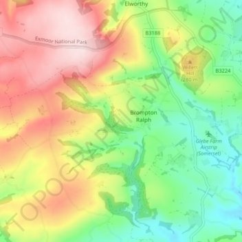
Brompton Ralph topographic map
Click on the map to display elevation.
About this map
Name: Brompton Ralph topographic map, elevation, terrain.
Average elevation: 224 m
Minimum elevation: 87 m
Maximum elevation: 393 m
Somerset trails, hiking, mountain biking, running and outdoor activities
Other topographic maps
Click on a map to view its topography, its elevation and its terrain.
Pleamore Cross
United Kingdom > England > Somerset > Somerset West and Taunton > Rockwell Green > Pleamore Cross
Average elevation: 125 m
Leighland Chapel
United Kingdom > England > Somerset > Somerset West and Taunton > Old Cleeve
Average elevation: 226 m
Luccombe
United Kingdom > England > Somerset > Somerset West and Taunton > Luccombe
Average elevation: 157 m
Hillfarrance
United Kingdom > England > Somerset > Somerset West and Taunton > Hillfarrance
Average elevation: 41 m
Nailsbourne
United Kingdom > England > Somerset > Somerset West and Taunton > Kingston St. Mary > Nailsbourne
Average elevation: 66 m