Geolocate

Strete topographic map

Click on the map to display elevation.

About this map

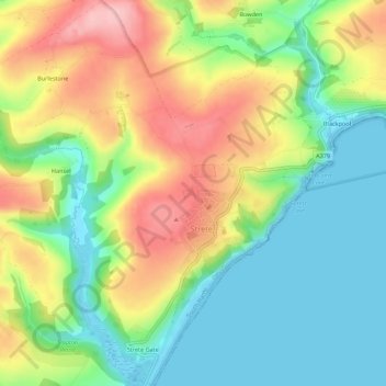
Name: Strete topographic map, elevation, terrain.

Location: Strete, South Hams, Devon, Devon and Torbay, England, United Kingdom (50.29550 -3.66284 50.33042 -3.61012)

Average elevation: 65 m

Minimum elevation: -1 m

Maximum elevation: 159 m

Devon trails, hiking, mountain biking, running and outdoor activities

Other topographic maps

Click on a map to view its topography, its elevation and its terrain.

Strete Gate

United Kingdom > England > Devon > South Hams > Strete > Strete Gate

Average elevation: 41 m

Gear up for your next adventure:

💧Hydration Reservoirs - Convenient water bladders for hands-free drinking on the move
🧦Merino Wool Hiking Socks - Moisture-wicking socks to prevent blisters during long mountain walks
🧵Survival Paracord - Multi-purpose cordage for emergency repairs and shelters
🥾Men's Waterproof Hiking Boots - Durable footwear with deep lugs for muddy and rocky UK terrains
🎿Telescopic Trekking Poles - Reduces knee strain on steep topographic descents

As an Amazon Associate, this site earns from qualifying purchases at no extra cost to you.