
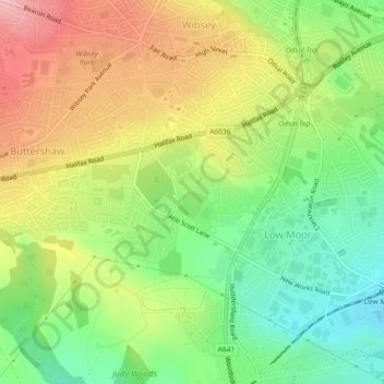
Harold Park topographic map
Interactive map
Click on the map to display elevation.
About this map
Name: Harold Park topographic map, elevation, terrain.
Average elevation: 208 m
Minimum elevation: 136 m
Maximum elevation: 294 m
Other topographic maps
Click on a map to view its topography, its elevation and its terrain.
Sea Moor Dike
United Kingdom > England > West Yorkshire > Bradford > Addingham
Sea Moor Dike, Addingham, Bradford, West Yorkshire, England, LS29 0LH, United Kingdom
Average elevation: 232 m
Broad Folds
United Kingdom > England > West Yorkshire > Bradford > Broad Folds
Broad Folds, Clayton, Bradford, West Yorkshire, England, BD14 6AQ, United Kingdom
Average elevation: 229 m
Girlington
United Kingdom > England > West Yorkshire > Bradford
Girlington, Manningham, Bradford, West Yorkshire, Yorkshire and the Humber, England, BD8 9NS, United Kingdom
Average elevation: 161 m
Haworth, Cross Roads and Stanbury
United Kingdom > England > West Yorkshire > Bradford > Stanbury
Haworth, Cross Roads and Stanbury, Stanbury, Bradford, West Yorkshire, Yorkshire and the Humber, England, United Kingdom
Average elevation: 332 m
Exley Head
United Kingdom > England > West Yorkshire > Bradford > Exley Head
Exley Head, Bradford, West Yorkshire, Yorkshire and the Humber, England, BD22 7EH, United Kingdom
Average elevation: 203 m