
Thank you for supporting this site ❤️
Make a donation
Make a donation
Gear up for your next adventure:
As an Amazon Associate, this site earns from qualifying purchases at no extra cost to you.
Xaagá topographic map
Click on the map to display elevation.
Thank you for supporting this site ❤️
Make a donation
Make a donation
Gear up for your next adventure:
As an Amazon Associate, this site earns from qualifying purchases at no extra cost to you.
About this map
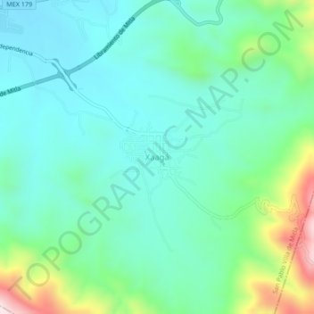
Name: Xaagá topographic map, elevation, terrain.
Location: Xaagá, San Pablo Villa de Mitla, Oaxaca, 70430, Mexico (16.88306 -96.34778 16.92306 -96.30778)
Average elevation: 1,821 m
Minimum elevation: 1,694 m
Maximum elevation: 2,227 m
Thank you for supporting this site ❤️
Make a donation
Make a donation
Gear up for your next adventure:
As an Amazon Associate, this site earns from qualifying purchases at no extra cost to you.