Geolocate

Wenvoe topographic map

Click on the map to display elevation.

About this map

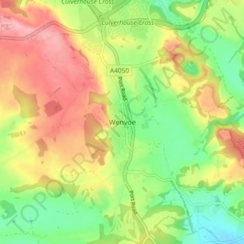
Name: Wenvoe topographic map, elevation, terrain.

Location: Wenvoe, Vale of Glamorgan, Wales, CF5 6AR, United Kingdom (51.42915 -3.28558 51.46915 -3.24558)

Average elevation: 72 m

Minimum elevation: 12 m

Maximum elevation: 138 m

Vale of Glamorgan trails, hiking, mountain biking, running and outdoor activities

Other topographic maps

Click on a map to view its topography, its elevation and its terrain.

Penarth

United Kingdom > Wales > Vale of Glamorgan

Average elevation: 17 m

Barry

United Kingdom > Wales > Vale of Glamorgan

Average elevation: 29 m

Dinas Powys

United Kingdom > Wales > Vale of Glamorgan

Average elevation: 30 m

St. Athan

United Kingdom > Wales > Vale of Glamorgan > St Athan

Average elevation: 30 m

Romilly Park

United Kingdom > Wales > Vale of Glamorgan > Barry

Average elevation: 26 m

Barry

United Kingdom > Wales > Vale of Glamorgan

Average elevation: 29 m

Barry

United Kingdom > Wales > Vale of Glamorgan

Average elevation: 29 m

Barry

United Kingdom > Wales > Vale of Glamorgan

Average elevation: 29 m

Gear up for your next adventure:

🔋Solar Power Banks - Keep your GPS and phone charged during multi-day expeditions
🧼Biodegradable Soap - Leave-no-trace hygiene for multi-day mountain treks
🛌Sleeping Mats - Insulated mats for comfortable outdoor sleeping
🧥Softshell Jackets - Breathable jackets for active outdoor use
📷Camera Straps - Secure straps for carrying cameras while walking

As an Amazon Associate, this site earns from qualifying purchases at no extra cost to you.