Geolocate

Tucker topographic map

Click on the map to display elevation.

Tucker

Tucker, at 1,117 feet (340 m) feet above sea level, is the highest point of elevation on the railroad line between Atlanta and Richmond, Virginia.

About this map

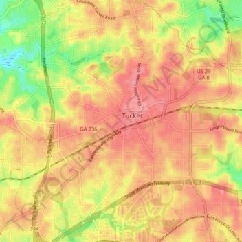
Name: Tucker topographic map, elevation, terrain.

Location: Tucker, DeKalb County, Georgia, 30084, United States (33.81841 -84.25263 33.88497 -84.17313)

Average elevation: 317 m

Minimum elevation: 267 m

Maximum elevation: 344 m

Gear up for your next adventure:

🔭Compact Hiking Binoculars - Lightweight optics for scouting terrain and spotting wildlife
🦯Walking Poles - Supportive poles for long-distance walking
🧭Orienteering Compasses - Accurate compasses for map-based navigation
Lightweight Tents - Compact tents for backpacking and trekking
🥾Trekking Poles - Poles to improve stability on uneven terrain

As an Amazon Associate, this site earns from qualifying purchases at no extra cost to you.