
Jingdezhen topographic map
Interactive map
Click on the map to display elevation.
About this map
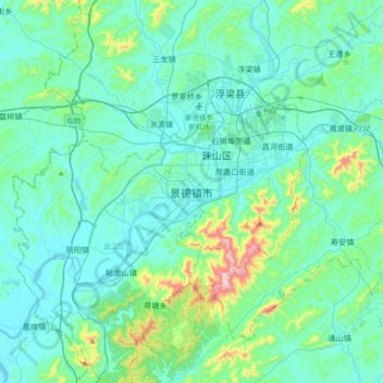
Name: Jingdezhen topographic map, elevation, terrain.
Average elevation: 100 m
Minimum elevation: 14 m
Maximum elevation: 612 m
Jingdezhen is situated in the north-east of Jiangxi and borders on Anhui; the city center area is located in the north-east of the Poyang Lake Plain. Its area is 5,256 km2 (2,029 sq mi).[10] The highest point is 1,618 m (5,308 ft), with plains on the southern part having an average altitude of 200 m (660 ft).