
Thank you for supporting this site ❤️
Make a donation
Make a donation
Gear up for your next adventure:
As an Amazon Associate, this site earns from qualifying purchases at no extra cost to you.
Alvidrón topographic map
Click on the map to display elevation.
Thank you for supporting this site ❤️
Make a donation
Make a donation
Gear up for your next adventure:
As an Amazon Associate, this site earns from qualifying purchases at no extra cost to you.
About this map
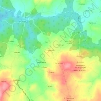
Name: Alvidrón topographic map, elevation, terrain.
Location: Alvidrón, Antas de Ulla, Ulloa, Lugo, Galicia, 27579, España (42.78732 -7.92190 42.82732 -7.88190)
Average elevation: 501 m
Minimum elevation: 454 m
Maximum elevation: 567 m
Thank you for supporting this site ❤️
Make a donation
Make a donation
Gear up for your next adventure:
As an Amazon Associate, this site earns from qualifying purchases at no extra cost to you.
Other topographic maps
Click on a map to view its topography, its elevation and its terrain.
Complexo Castrexo do Castro de Seoane
España > Galicia > Ulloa > Antas de Ulla > Sendelle
Average elevation: 544 m